Dimdima
Online Children's Magazine from India
Dimdima
Online Children's Magazine from India


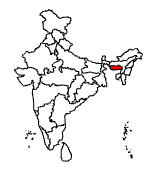
Meghalaya in northeastern India rests on the northeastern shoulder of Bangladesh, south of the state of Assam. A part of Assam at the time of Indian Independence, Meghalaya became a separate state in 1972.
Area : 22,429 sq. km
Population : 23,06,069.
Languages : Khasi and Garo are the principal languages and, together with Jaintia and English, are the official languages.
Capital : Shillong
Location :
Meghalaya occupies a mountainous plateau and lies in an earthquake-prone area. An earthquake in 1896 destroyed its capital, Shillong. It was rebuilt and is today referred to as the "Scotland of the East" on account of its undulating landscape and sylvan surroundings.
Though Shillong is connected by air to Calcutta and Guwahati, it has only 1000 kilometres of surfaced roads and the nearest railway station lies in Assam.
People :
The inhabitants of Meghalaya are mainly tribal�hailing from the Khasi, Jaintia and Garo tribes. A common cultural tradition of all these tribes is the matriarchal law of inheritance. Property and succession of family position passes from the mother to the youngest daughter.
Agriculture is the main economic activity. For long, the tribes practised shifting cultivation but are gradually moving to more settled ways of life. The more important crops are rice and maize. Oranges, pineapples, and potatoes are also grown, as are arecanut, ginger, turmeric, betel leaf and black pepper.
Climate :
The state is drained by a number of rivers, none of which are navigable due to rocky beds and strong currents.
The high altitude and the constant cloud cover keep temperatures low throughout the year. Even in summer, the temperature does not cross 23 degrees Celsius. The state has been aptly named because Meghalaya means "Abode of the Clouds."
The hills facing south towards Bangladesh receive some of the heaviest rainfall in the world.
The inhabitants of Meghalaya are mainly tribal�hailing from the Khasi, Jaintia and Garo tribes. A common cultural tradition of all these tribes is the matriarchal law of inheritance. Property and succession of family position passes from the mother to the youngest daughter.
Agriculture is the main economic activity. For long, the tribes practised shifting cultivation but are gradually moving to more settled ways of life. The more important crops are rice and maize. Oranges, pineapples, and potatoes are also grown, as are arecanut, ginger, turmeric, betel leaf and black pepper.
Khasi and Garo are the principal languages and, together with Jaintia and English, are the official languages.
Though Shillong is connected by air to Calcutta and Guwahati, it has only 1000 kilometres of surfaced roads and the nearest railway station lies in Assam.
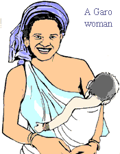
The Khasi, Garo and the Jaintia tribes are the original inhabitants of Meghalaya and the state still has a predominantly tribal population. Their cultural traits and ethnic origins remain distinctive, mainly due to their long geographical isolation.
The Khasi and Jaintia trace their ancestry to the Mongolian race.
The Garo, on the other hand, belong to the Tibeto-Burman race and are also called A'chik. They originally predominated in the Garo Hills. To British travellers in the 19th century, the Garos appeared as "bloodthirsty savages". Like the other tribes, the Garo lived in permanent villages with the headman or nokma as a leader.
The British moved into the area in the early 19th century, when Burmese incursions became more frequent and France emerged as a rival colonial power in Indochina. Between 1826 and 1836, all the small tribal principalities in the region were incorporated into British dominions. But the principalities, resenting the loss of autonomy and intrusion of outsiders, frequently rebelled.
In 1828, the Khasi, later aided by the Garo, first revolted, against the construction of a highway through their domains, which saw a large-scale intrusion of Englishmen and Bengalis in the area. The revolt was ruthlessly suppressed in 1833.
To curb the repeated uprisings, the British merged these areas into the state of Assam, with Shillong as the new capital in 1874.
Shillong which is said to derive its name from the deity Shyllong became a favourite holiday resort of the British.
After independence, the hill tribes within Assam agitated for a separate state. Thus, the Indian government created the new state of Meghalaya in 1972, comprising the districts within the Garo, Khasi, and Jaintia hills. Shillong became the capital of the new state.
Meghalaya presents a panorama of rolling hills, pine forests, roaring waterfalls, lakes and a multitude of flora and fauna. But among the many natural wonders found in abundance throughout the state, the caves are unique. There are over 200 caves; many of them still unexplored.
Shillong and the surrounding areas offer several attractions. The horseshoe-shaped Ward Lake is set amidst a landscaped botanical garden. The 18-hole Shillong golf course, one of the best in India, was laid out 90 years ago by the British. The Butterfly Museum has a good display of mounted butterflies and beetles.
Umiam and Naphak lakes attract the fishing enthusiasts, bird watchers and the sports buffs who enjoy its boating, sailing and water skiing facilities. For an acquaintance with the local crafts, the Bara Bazaar is a shopper's delight.
Cherrapunjee, more famous as the rainiest place on earth also has gushing waterfalls like the famed Nohsngithiang falls. The town has limestone caves and its orange honey is also popular.
Mawsynram, which recently recorded more rainfall than Cherrapunji, developed into a pilgrimage centre after the discovery of a cave with a giant stalagmite shaped like a shivalinga.
Some of the most beautiful caves are found in the Jaintia and Garo Hills. Krem Um-Lawan a beautiful cave with numerous cataracts and waterfalls, is the longest and deepest cave in South Asia. Siju-Dobkhakol, in the Garo Hills, is the third largest cave in South Asia. It is home to innumerable bats. Tetengkol-Balwakol, the "cave of dwarfs with inverted feet", has an entrance barely a metre high but it hides a cave nearly 5000 metres long.
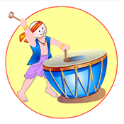
Several festivals are observed to mark the changing seasons. In Shillong, Shad Suk Mynsiem, a two-day folk festival, is celebrated during April. The Nongkrem Dances are a 5-day festival commemorating the harvest season. In the Garo hills the harvest is celebrated in November with the Wangala, the 100 Drums Festival.

Dimdima is the Sanskrit word for ‘drumbeat’. In olden days, victory in battle was heralded by the beat of drums or any important news to be conveyed to the people used to be accompanied with drumbeats.
Bharatiya Vidya Bhavan
K. M Munshi Marg,
Chowpatty, Mumbai - 400 007
email : editor@dimdima.com
Bharatiya Vidya Bhavan
505, Sane Guruji Marg,
Tardeo, Mumbai - 400 034
email : promo@dimdima.com
Dimdima.com, the Children's Website of Bharatiya Vidya Bhavan launched in 2000 and came out with a Printed version of Dimdima Magazine in 2004. At present the Printed Version have more than 35,000 subscribers from India and Abroad.