Dimdima
Online Children's Magazine from India
Dimdima
Online Children's Magazine from India


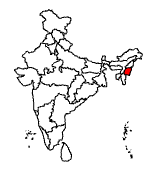
Manipur literally means the land of the gems. This north-eastern state surrounded by Nagaland, Assam and Mizoram has an international border with Burma in the east. Manipur formally became a part of the Indian Union in 1949 and a state in 1972.
Area : 22,327 square kilometres
Population : 23,88,068.
State Language : Manipuri.
Capital : Imphal.
Literacy rate : 59.9%.
Physiography :
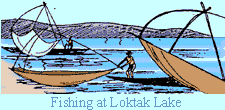
Manipur is geographically divided into two distinct tracts� hills and plains. Manipur's hill ranges form parts of the Indo-Burmese Mountain arc, often referred to as the eastern arm of the Himalayas. Though predominantly a hill state, it is watered by the rivers Imphal, Iril, Thoubal, Irang and Barak, which flow from north to south. At its centre is Lake Loktak into which several rivers drain. There are other lakes in the central area. They are used for fishing and duck shooting as well as for boat races.
To the south of Lake Loktak is the Keibul Lamjao game sanctuary famous for its brow- antlered deer found only in Manipur. The Loktak multi-purpose project completed in 1982, has made an impact on the economic development of north-eastern India.
General Information :
More than 2/3rds of the state's area is covered by forests, but these forests are poor in quality and difficult to access. Bamboo and teak are common and magnolia and oak, widespread. Elephants, rhinoceroses and tigers were once common in these forests.
People :
The characteristics of the Manipuri people vary according to geographical divisions.
The Meitees who speak Manipuri, inhabit the plains, while the Kukis and Nagas of the hills, speak different Tibeto-Burmese dialects. Manipuris are enthusiastic polo players, and the game of polo is said to have originated here. 'Mukna-Kangjei', Manipuri free style hockey-cum-wrestling and 'Yubi-Lakpi', a game involving coconut-snatching, are traditional Manipuri games that are simply fascinating to watch.
Climate :
Manipur enjoys a sub-tropical monsoon climate. January is the coldest month and July the hottest. Rainfall on the whole is abundant in the state.
More than 2/3rds of the state's area is covered by forests, but these forests are poor in quality and difficult to access. Bamboo and teak are common and magnolia and oak, widespread. Elephants, rhinoceroses and tigers were once common in these forests.
The characteristics of the Manipuri people vary according to geographical divisions. The Meitees who speak Manipuri, inhabit the plains, while the Kukis and Nagas of the hills, speak different Tibeto-Burmese dialects. Manipuris are enthusiastic polo players, and the game of polo is said to have originated here. 'Mukna-Kangjei', Manipuri free style hockey-cum-wrestling and 'Yubi-Lakpi', a game involving coconut-snatching, are traditional Manipuri games that are simply fascinating to watch.
The state language of this predominantly agricultural state is Manipuri.
King Pamheiba who ruled in the Manipal region from 1709 to 1748 was feared by his neighbours, the Burmese � and for good reason. He had an aggressive policy towards the Burmese and on one occasion his soldiers reached as far as Ava, their capital.
He was known for his kindness to the poor.
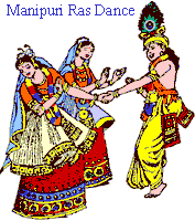
After his death, Manipur fell apart due to Burmese invasions and internal strife. Seven clans ruled different areas until Rajarshi Bhagya Chandra unified Manipur. He repelled the Burmese and popularized the Manipuri Ras dances.
In 1819, the Burmese occupied the region and the three Manipuri princes � Marjit, Chaurjit and Gambhir Singh, sons of Bhagya Chandra escaped to Chachar. Gambhir Singh regained Manipur with British help but soon afterwards Manipur became a British protectorate. Gambhir Singh died in 1834 and a British political agent was appointed in 1835.
In 1890, the Raja of Manipur was deposed by his general. The British Chief Commissioner of Assam, Quentin and four others marched to Manipur with a small force but they were captured and killed. A strong British force was then sent. The Raja and the Senapati were captured and executed. A boy raja, Churachand was installed on the throne and during his minority rule, the British political agent administered the state.
Churachand abdicated in favour of his son, Bodhchandra during whose reign the Japanese forces occupied much of Manipur and there was fierce fighting between them and the Allied forces. The INA also fought the British in Manipur,
Bodhchandra signed the merger agreement with the Indian government in 1949 and Manipur became part of India as a Union Territory. In 1972, it attained statehood.
Imphal, its capital is one of the oldest state capitals of India. Founded about 2000 years ago it derives its name from Yumpham meaning homestead.
Manipur, in India's northeast, is blessed with a rich cultural heritage and verdant scenic beauty.
In Imphal, the Govindajee Temple dedicated to Vishnu is a beautiful structure with gold domes, a paved court and a large congregation hall. In Kaina, is a temple built by Kin Bhagyachandra, with the image of Krishna carved out of a jackfruit tree.
The Loktak Lake is a miniature inland sea. Fishermen harvest the water chestnut here, and build their houses on islands of floating weeds.
Langthabal on the Indo- Burma Road has an old historic palace, well-planned temples and ceremonial houses amidst pine and jackfruit trees.
In Moirang is an ancient temple of the deity Thangjing. Every May, men and women, in traditional costumes, sing and dance in the god's honour. The flag of the Indian National Army was first hoisted here, on April 14, 1944. An INA Museum exhibits letters, photographs, badges of ranks and a bronze statue of Netaji in uniform. The British and the Indian army cemeteries honouring those killed in the Second World War are at Moirang and Khongjom. At Khongjom there is also a memorial to Paona Brajabashi, a great warrior who died fighting the British in 1891. Khongjom Day is a State holiday observed every year on April 23.
Khonghampat Orchidarium has more than 110 varieties of orchids, including several rare species.
A wide range of handloom material and artistic handicrafts from bamboo, papier mache and ivory, are sold at Khwairamband market, said to be the largest exclusively managed women's market in the country.
The Manipuri classical dance, a dance form in which the body moves with slow sinuous grace, evolved in the 8th century.
Important festivals of Manipur are the Dol Yatra in March, Rath Yatra in June-July and Durga Puja in September-October. Manipuris celebrate their New Year in the second week of April.
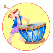
Dimdima is the Sanskrit word for ‘drumbeat’. In olden days, victory in battle was heralded by the beat of drums or any important news to be conveyed to the people used to be accompanied with drumbeats.
Bharatiya Vidya Bhavan
K. M Munshi Marg,
Chowpatty, Mumbai - 400 007
email : editor@dimdima.com
Bharatiya Vidya Bhavan
505, Sane Guruji Marg,
Tardeo, Mumbai - 400 034
email : promo@dimdima.com
Dimdima.com, the Children's Website of Bharatiya Vidya Bhavan launched in 2000 and came out with a Printed version of Dimdima Magazine in 2004. At present the Printed Version have more than 35,000 subscribers from India and Abroad.