Dimdima
Online Children's Magazine from India
Dimdima
Online Children's Magazine from India


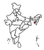
Tripura, in northeastern India is the third smallest state, after Sikkim and Goa.
Tripura was ruled by kings of the Manikya dynasty until 1949 when it became part of the Indian Union
Area : 10,491.69 sq.km.
Population: 31,91,168
Capital : Agartala
Main Languages: Bengali and Kokborak
Location :
It is surrounded by Bangladesh on all sides except for a narrow strip in the northeast where it shares boundaries with Assam and Mizoram.
Physiography :
Tripura is hilly with several deep river valleys. The hills are covered with thick forests and extensive bamboo groves. The south is more open and most of the people live there. The capital, Agartala, is also in the south.
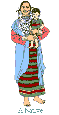
People :
The people, the majority of whom are tribals, live in houses built on a raised platform, 3 to 4 metres above the ground, and reached by a ladder. Immigrants from West Bengal and Bangladesh have settled in the state and reduced the tribals to a minority in some areas.
Two militant groups, the National Liberation Front of Tripura and the All Tripura Tiger Force both want the non-tribals who have settled in Tripura after 1949 to leave.
Economy :
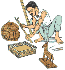
Agriculture is the mainstay of the economy, with shifting cultivation gradually being replaced by modern farming methods. While rice is the main food crop, wheat, potatoes and sugarcane are also grown. Tea is the main cash crop. Industry is generally small in scale and includes saw mill, manufacture of aluminium utensils and handloom weaving.
The state has abundant reserves of natural gas and gas-based industries are coming up.
Not much is known about Tripura's early history. It first finds mention in the Ashokan pillars of the 3rd century BC. In the 1300s, Tripura came under the control of the Manikya dynasty, a family of Indo-Mongolian origin.
In the early 17th century, Tripura came under the domination of the Mughals. But the local rulers, the Manikyas still retained some of their power. After the British set up their colonies in Calcutta, they conquered parts of modern Tripura but exerted no administrative control for more than a century. To the British, Tripura was known as Hill Tippera. Even when a representative was appointed in 1871, the Manikya maharajas had adequate independence, though they were required to seek British recognition on the accession of a new ruler.
One of the greatest of the Manikya rulers was Bir Chandra Manikya Bahadur of the 19th century. He was an accomplished poet and musician and made an effort at modernization by reorganizing Tripura's administration and abolishing the practice of slavery and sati. The last ruling maharaja of Tripura, Bir Bikram Kishore Manikya, ascended the throne in 1923 and, before his death in 1947, settled that Tripura should accede to the newly independent country of India. Tripura officially became part of India on Oct. 15, 1949, and was made a union territory on Sept. 1, 1956. It became a constituent state of the Indian Union on Jan. 21, 1972.
Agartala, the capital of Tripura has numerous palaces and temples. Ujjayanta, the former residence of the royal family was built in 1901; Neermahal built in the midst of a lake was used as a summer palace. It is the only lake palace in eastern India.
Nobel laureate Rabindranath Tagore stayed at Kunjaban palace, constructed in 1917. Part of it is now open to the public.
Tripura is divided into three districts: North Tripura, West Tripura and South Tripura. The headquarters of South Tripura is Udaipur.
The Mata Tripureshwari temple in Udaipur is dedicated to the goddess Kali. A large fair is held here every year during Diwali.
Among the more intriguing sights of Tripura are its rock-cut carvings. Huge carvings on near-vertical walls of rock can be seen in Unnakoti, which was built in hilly inaccessible terrain in South Tripura to avoid destruction by invaders. Unnakoti is an important place of pilgrimage in the state. Rock carvings can also be seen at Debtamura, on the banks of the Gomti. The rocks on the banks of the river are carved with images of Shiva, Vishnu, Kartik, Durga and other deities. The carvings date back to the 15th and 16th centuries.
Music and dance are an integral part of Tripura’s tribal communities. The Raengs dance the Hozagiri dance with a lighted lamp on their heads. The Bizu dance of the Chakmas, the Hai Hak dance of the Halams, the Wangala dance of the Garos, the Cherow dance of the Darlong tribe and the traditional lamp dances of the Mog community reflect the cultural diversity of the state.
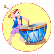
Dimdima is the Sanskrit word for ‘drumbeat’. In olden days, victory in battle was heralded by the beat of drums or any important news to be conveyed to the people used to be accompanied with drumbeats.
Bharatiya Vidya Bhavan
K. M Munshi Marg,
Chowpatty, Mumbai - 400 007
email : editor@dimdima.com
Bharatiya Vidya Bhavan
505, Sane Guruji Marg,
Tardeo, Mumbai - 400 034
email : promo@dimdima.com
Dimdima.com, the Children's Website of Bharatiya Vidya Bhavan launched in 2000 and came out with a Printed version of Dimdima Magazine in 2004. At present the Printed Version have more than 35,000 subscribers from India and Abroad.